Make the Carrollton square your meeting point
Use the Historic Downtown parking guide to choose a shared approach and leave time for a block on foot.
In this article
A visit to Downtown Carrollton can begin with three people coming from three different directions. One might ride DART, another might park nearby and a third might already be on the way from a local business. Give those arrivals a single meeting point in or around the square before choosing the rest of the outing. The city’s parking information and DART’s station page can help each person decide how to approach it. Once you are together, pick the short walk or stop you have time to enjoy.
Start with the City of Carrollton’s downtown parking page and the DART Downtown Carrollton Station information. The city provides a map and posts changes that can affect parking. DART locates the station near the historic square and describes a pedestrian connection over Belt Line Road. Check the latest directions for the day you intend to go and follow signs at the site.
Name a visible point inside the square
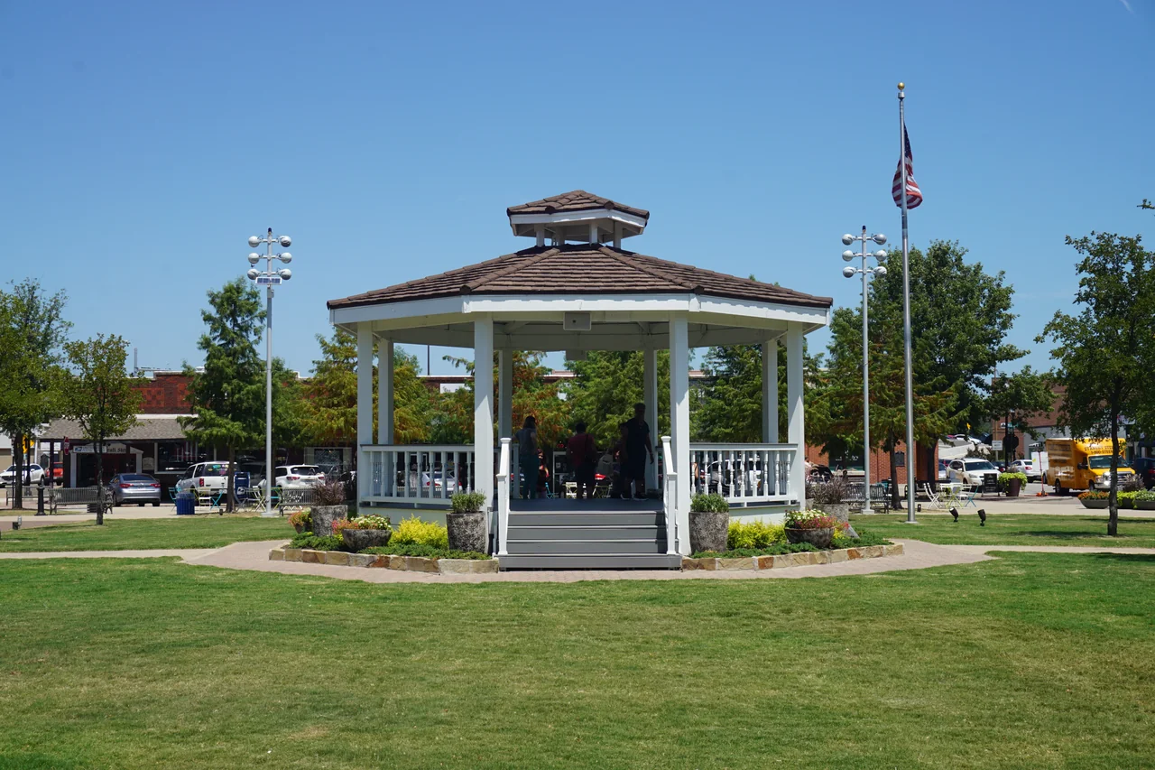
Choose an agreed public location that can be identified from an approach to the square. The city's history of Downtown Carrollton Square describes the gazebo and its role as a place for community events. The gazebo may help people orient themselves even if the group decides to meet elsewhere in the vicinity. Tell people which side or approach you mean and where the group can wait without blocking the route. A first-time visitor should be able to recognize the instructions independently.
If you use the square as the destination in a message, add the exact place you intend to wait. Two people can both arrive downtown while looking for each other from different streets. A practical direction might specify a permitted side of the square and a recognizable feature. Agree what to do if the usual point is in use or difficult to reach on that day. Update the group if your meeting is moved so nobody has to make a second circuit to find you.
Match the plan to the route from the station
The DART station page describes access from its aerial station near Belt Line Road and Broadway Street and identifies Green Line service. Use the current operator map and alerts to plan the ride and the walk from the station. If you are arranging to meet someone there, say whether you intend to wait at the station or continue to the square. That is a different agreement from asking them to meet at a particular feature downtown. Give them time to follow the pedestrian route rather than assuming that reaching the rail stop puts them at the meeting site.
Check the arrangements that matter to a person’s actual journey. Some visitors may want information about accessible approaches, transferring to another service or which route to use when an area of the station is temporarily unavailable. Ask DART for the current information if a particular detail is essential. Give the person an agreed contact if their arrival changes. This lets the rest of the group decide whether to wait at the square or move together once everybody is able to meet.
Choose parking using the current city information
A space near the square can be useful, although access and rules can change depending on construction, events and the specific street or lot. Read the city’s current notices as part of the trip. Tell the people driving which part of town you plan to meet and give them enough room in the schedule to find an approved space and walk from it. Follow signs governing the spot you actually use. A lot shown on an older map may be affected by a change announced on the city’s parking page.
If you are traveling with someone who would prefer a short approach or a particular place to wait, plan the part between the vehicle and the gathering spot. Review the city’s information about accessible parking and consider the specific route the person would need afterward. Contact the city about any detail that must be confirmed. A person meeting the group may want to reach the chosen spot in a different way from the driver. Agree on the time and place they will use to reunite.
Build a small circuit or choose a single stop
Once the group has arrived, decide whether you want to stay in one place or use the square as the beginning of a short walk. The city’s published zoning definitions identify the square’s boundaries by Elm Street, Main Street, Broadway and Fourth Street. That description is a reference for understanding its location. Use the signs and available pedestrian routes to decide where to go. Give the group a second named point to reach if you want to take a short circuit.
Someone already committed to an appointment may be able to spend time only at the square itself, looking at a feature or starting an errand nearby. Others may have enough time to choose an additional stop. Check what each person wants before walking farther. Tell the group when you plan to return and what can be left for another visit. A small plan keeps the square useful as a common point even when people have different lengths of time.
Pay attention to where the public space meets the streets
Look at the relationship between the part of the square where you are standing and the streets that bring people into it. Someone interested in local history can read the city’s account of the gazebo and then observe how a recognizable landmark helps people find the same meeting point today. A child can point out an approach they would recognize on a second visit. Ask how they know where they are rather than giving them a set of directions to remember right away.
The walk can include a short look at how storefronts, sidewalks and the square shape the area. Choose a suitable public place to pause and look. If there is activity around the gazebo or on an adjoining street, take the current conditions into account and keep the path clear. A closer look at a building or other feature might deserve a later visit. Give that outing a source to consult and a question to carry rather than assuming a first glance explains the whole street.
Plan for a junction where the group may separate
If one person is heading back to the station and another wants to continue nearby, arrange where the shared part of the visit ends. Make sure that everybody knows the route they intend to take and which current information they should check. The square can be a useful point to say goodbye whether people arrived together or separately. If you need to meet again afterward, agree on a time and specify the exact side or feature in the same way you did at the start.
An event can make meeting or crossing more complicated. Check the city’s current information before choosing a place that depends on access through an event area. Let people know where to go when a route is not available and allow enough time before another fixed commitment. If you return on an ordinary day, check whether a shorter approach now works. Use the named public features in the same way while letting the occasion determine how much of the area you can cover.
Keep the directions that actually worked
When another person asks about a meeting place afterward, give them one detail for the last part of the approach. The station helps someone decide which route to use across Belt Line Road. The square itself can tell them which public feature to head toward once they reach the surrounding streets. Keep a separate reference for the arrival and the meeting point if people are starting in several different places. That makes the shared part of the outing clearer without requiring everybody to use one route.
If you use the historical gazebo as an orientation point, look for the location in the city's history before deciding which way to approach. The archival photograph accompanying this article shows what the gazebo looked like in July 2019. Check current signs and conditions for your own visit. A named location can remain a useful reference when an event changes the way people wait or pass through the square from one side.
Write the start and end of a route in the same message when you share it, then ask which part another visitor would still want to confirm.
At the end of the visit, tell the next person which landmark helped you arrive and what route made it easy to leave. Note any temporary condition separately so another visitor knows to check it. A route that worked on foot after using the train gives a different kind of information from a place somebody found from the street after parking. Use the official sites to verify the conditions before carrying a specific assumption into the next outing.
For a different trip, choose another reason to come. You might walk a different approach, spend more time with one piece of history or use the meeting point before visiting a nearby public destination. The square gives people a common place to start. The rest of the day can be changed as long as everyone understands where to come first and how to reach it.
Read more Downtown Carrollton features in the Carrollton Tribune archive.
Sources
- City of Carrollton’s downtown parking pagecityofcarrollton.com
- DART Downtown Carrollton Station informationdart.org
- history of Downtown Carrollton Squarecityofcarrollton.com
- published zoning definitionscityofcarrollton.com