A wooded visit at Carrollton’s Elm Fork Nature Preserve
Use the facility listing to check access and read the trail rules before entering.
In this article
A wooded visit at Carrollton’s Elm Fork Nature Preserve
At the end of a drive through the McInnish Sports Complex, Carrollton’s Elm Fork Nature Preserve changes the pace of a visit. The first part of the walk is close to fields and parking. The path soon goes under trees and continues toward a pond. You can turn back after a few minutes under the canopy or build a longer visit around the water. The trip works best when you plan for the soft surface and for the fact that the preserve’s trail, nature center and neighboring park facilities have different uses and access rules.
Head for the trail entrance inside McInnish
The city facility page lists 2335 Sandy Lake Road and places the preserve inside the McInnish Sports Complex. The Dallas County preserve listing labels the entrance with 2430 Sandy Lake Road and specifies that it is at the end of the road into the sports complex. Both descriptions point visitors into McInnish. For the last turns, use the city’s directions to the place labeled Elm Fork Nature Preserve Trail or Elm Fork Nature Preserve Trail Entrance. The plant survey identifies the trailhead beside the parking area at a kiosk and benches. Check current signs after parking, especially if a field event has changed traffic around the complex.
Dallas County says high water can restrict access to McInnish. A walk may be unsuitable even when you have sun overhead and time to go. Rain over the preceding day or two can leave an unpaved route slippery, and a low point can retain water after nearby streets look dry. Check the city’s guidance if the area has had heavy rain and treat a gate or closure sign as your turnaround. A large park complex can have a clear entrance at the highway while a later section of a drive is closed. Keep enough flexibility to choose a different walk if you cannot reach the trailhead.
Carrollton lists daily trail access from dawn to dusk and no admission charge. Dallas County’s hours begin half an hour before sunrise and extend half an hour after sunset. A first visit planned within full daylight works with both listings, gives you better visibility under the trees and makes the final walk to parking simpler. If you plan to come near either end of the day, check current access and posted directions with the city. Bring the people you are meeting the same remaining time you would allow yourself. A last-minute arrival gets harder when a group has already left the entrance.
Set the pond or the first bench as your destination
Carrollton’s trail directory lists the Elm Fork trail at 0.78 mile. Dallas County describes a roughly one-mile soft-surface walk that leads through woodland to a pond and farther to a lookout at an inlet of the Trinity River. Use the distances as descriptions of scale. Choose a turnaround by time and a feature you can identify on the current trail map. The trail can feel longer to somebody stopping to look at roots and leaves or to a family keeping a child close on uneven ground.
For a brief first walk, start with the kiosk and a few minutes under the trees. Confirm the map’s orientation from the parking lot and trace the direction you expect to take. Choose a clearly marked junction or bench as your turnaround, then spend a little time at that point before returning. That gives you a chance to see how well the surface works for your party, how much shade you have and whether the weather is changing. If an adult wants to reach the main pond and a child needs a shorter trip, leave that different goal for another day or arrange for a second adult to accompany a longer walk.
Paving, width, grade and resting places matter more than the total mileage if you are bringing a mobility device or need a reliably firm surface. County guidance describes the trail as soft surfaced. A packed section can be followed by exposed roots, leaves or damp ground. Find out what a group needs before promising a full circuit. For a first outing at an unfamiliar preserve, an out-and-back between two points you can recognize when returning can be easier to judge than a loop that has new terrain all the way around. Keep to the marked route if high water or mud makes part of the trail impassable.
Look closely as the woods open to water
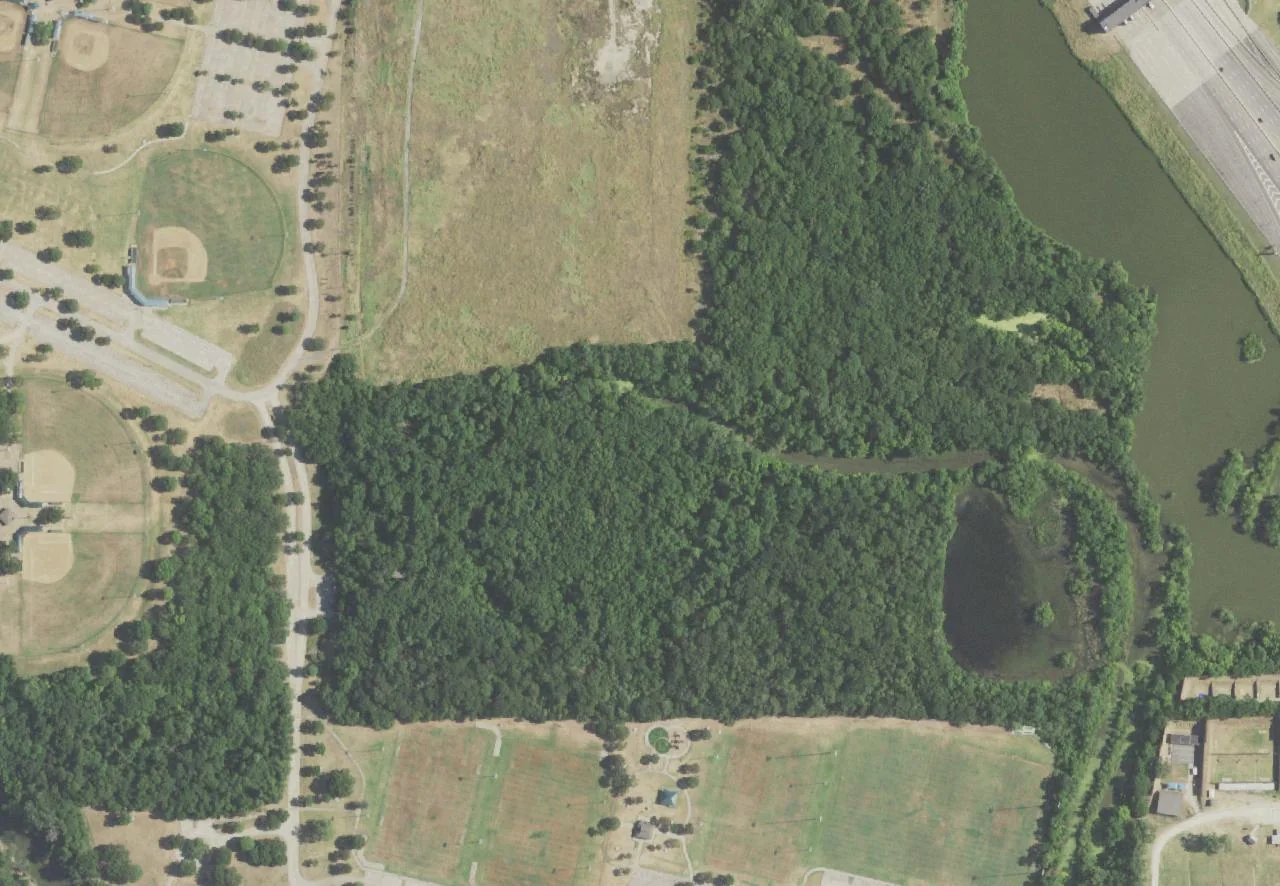
The aerial photo shows the tree cover between the sports grounds and the large pond on the east side. Under the canopy, a pond visit unfolds in stages. Water may be visible through branches before the whole edge comes into view. Select a clear established observation point and give yourself a minute to listen. A visitor can notice ripples or movement along the margin before a bird or other animal is easy to recognize. Binoculars and a notebook are more useful here than a route designed around continuously covering ground.
A first observation can be simple. Put the date, time and conditions on one page. Note whether an animal was on the water, over it or on a nearby branch, and whether you heard it before seeing it. Even observations without a species name give you something to compare on a return visit. With children, try looking in two directions from the same spot and asking what changed. The canopy can affect what you see and hear, and the brighter edge of the water may reveal more movement. Let another group pass if your position blocks the trail. Approach by the marked path and keep back from an unstable bank.
An older city plant inventory includes red mulberry, pecan and western soapberry among plants tied to points along the route. Use it as a record of what observers found, then look for present labels or make your own observations from the path. Tree cover, signs and small trail features can change over time. Details such as how a leaf is arranged and whether you can see bark shape or fruit are worth noting even if you leave the identification for later. A follow-up walk at another season may give you different clues.
You can also compare two places on the same day. Start with a minute beside the wooded edge nearest parking, where there may be noise from activity at the fields. Then repeat the observation from a wider point along the path, where sound and light may reach you differently. At either stop, sort what you hear into sounds you can locate, such as footsteps on the trail, and sounds you cannot place yet. People in the same group can make different observations from the spot. For children it can be a useful way to practice looking and listening without picking a leaf, collecting an object or getting closer to wildlife. The two locations may feel more alike in winter, with less foliage, than they do after spring growth. A third visit on a day with a breeze offers a way to test another difference while walking exactly the same stretch.
Give the nature center separate time
The city’s Elm Fork Nature Center information describes education and interpretive exhibits and lists 972-466-9811. Renovation plans included a more accessible connection from parking and new exterior decking, along with changes to the interior displays. Call about current opening and programming if seeing the inside matters to your party. An outdoor path may be available on a day when a building is closed, and a planned improvement can have its own completion, inspection and opening dates.
The site is also a place to explore a piece of Carrollton’s development. Dallas County tracks the preservation history to a woodland share called the Bramblitt Woodright, which the county history describes as a supply of wood for domestic needs. The county notes that the area was in Wichita territory before the colonization of Texas. Those histories sit alongside its present use for education and recreation. A family interested in the changes can look at how the woodland lies beside sports fields today and ask about the land that was set aside, what was cleared nearby and what the preserve makes possible for visitors.
Save a few minutes for the rules and the return
Dallas County lists preserve-specific restrictions on pets, fishing and smoking. The preserve sits near other public recreation in the complex, where signs and permitted uses can differ. For a visit that includes a dog, start with the city’s dog park directory and choose an appropriate destination ahead of time. For the wooded walk, bring a way to carry out food wrappers and other small items. The nature center recommends long pants and closed-toe shoes. Carry water for everyone, including during cooler months when a short route may seem like it will take very little time.
At the trailhead, do a last time check based on daylight and the slowest walker. If the pond is your goal, decide in advance how much time you will spend at the observation point and when you will start back. If the weather or footing changes, turn around where you can retrace your route comfortably. Back at the paved area, compare what you saw under trees with what you could see across the open parking and playing fields. For another outing with different surfaces or amenities, browse walking ideas in the Carrollton Tribune archive.
Sources
- city facility pagecityofcarrollton.com
- county historydallascounty.org
- trail directorycityofcarrollton.com
- city plant inventorycityofcarrollton.com
- city’s Elm Fork Nature Center informationcityofcarrollton.com
- dog park directorycityofcarrollton.com